Bar nearby Brasserie San Mario
France
Bar nearby Brasserie San Mario
Brasserie San Mario
204 Avenue de la République, Toulon France
contacts phone
:
+33
Latitude:
43.120007
, Longitude:
5.9324528
read more
nearest Bar
65 m
Le Graal
377 Avenue de la République, Toulon
Bar
read more
200 m
Davin Jacques Andre
18 Rue Grande, Seyne
Bar
read more
201 m
Le Gambetta
6 Place Gambetta, Toulon
Bar
read more
216 m
Le Neptunia
98 Avenue de la République, Toulon
Bar
read more
216 m
Calaveras
Port de Toulon,, 98 Avenue de la République, Toulon
Bar
read more
230 m
La Lampa
117 Quai de la Sinse, Toulon
Bar
read more
238 m
La Feuille de Chou
15 Rue de la Glacière, Toulon
Bar
read more
284 m
Le Roux
13 Rue Hoche, Toulon
Bar
read more
297 m
Le Messina
35 Rue Victor Micholet, Toulon
Bar
read more
308 m
Bootlegger
18 Rue de l'Équerre, Toulon
Bar
read more
356 m
Twiggy cafe
11 bis rue pierre semard, Toulon
Bar
read more
366 m
Atmosflair
Rond-Point Général Lefort, Toulon
Bar
read more
378 m
Aux 5 Parties du Monde
30 Rue Anatole France, Toulon
Bar
read more
390 m
Carré 2 Vigne
14 Rue de Pomet, Toulon
Bar
read more
433 m
Corsaire PUB
15 Rue Marquetas, Toulon
Bar
read more
447 m
La Banane
6 Place Louis Pasteur, Toulon
Bar
read more
544 m
Le Cellier d'Alexandre
254 Rue Jean Jaurès, Toulon
Bar
read more
553 m
La Régence
2 Bis Rue Henri Pastoureau, Toulon
Bar
read more
567 m
Van Gogh
6 Place d'Armes, Toulon
Bar
read more
600 m
Le Stromboli
40 Rue Picot, Toulon
Bar
read more
742 m
La Mi-Temps
1 Avenue François Cuzin, Toulon
Bar
read more
985 m
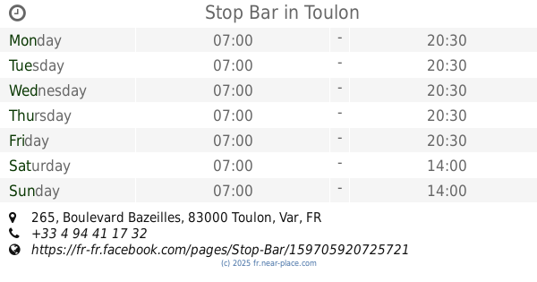
Stop Bar
265 Boulevard Bazeilles, Toulon
Bar
read more
995 m
Mokadmi Foued
25 Boulevard Bazeilles, Toulon
Bar
read more
1.042 km
Le Louisiane
12 Rue Montauban, Toulon
Bar
read more
1.065 km
Middle
13 Rue Castillon, Toulon
Bar
read more
📑
all categories
Accounting
Administrative area level 1
Administrative area level 2
Airport
Amusement park
Aquarium
Art gallery
Atm
Bakery
Bank
Bar
Beauty salon
Bicycle store
Book store
Bowling alley
Bus station
Cafe
Campground
Car dealer
Car rental
Car repair
Car wash
Casino
Cemetery
Church
City hall
Clothing store
Colloquial area
Convenience store
Country
Courthouse
Dentist
Department store
Doctor
Electrician
Electronics store
Embassy
Finance
Fire station
Florist
Food
Funeral home
Furniture store
Gas station
General contractor
Grocery or supermarket
Gym
Hair care
Hardware store
Health
Hindu Temple
Home goods store
Hospital
Insurance agency
Intersection
Jewelry store
Laundry
Lawyer
Library
Light rail station
Liquor store
Local government office
Locality
Locksmith
Lodging
Meal delivery
Meal takeaway
Mosque
Movie rental
Movie theater
Moving company
Museum
Natural feature
Neighborhood
Night club
Painter
Park
Parking
Pet store
Pharmacy
Physiotherapist
Place of worship
Plumber
Point of interest
Police
Political
Post office
Premise
Real estate agency
Restaurant
Roofing contractor
Route
Rv park, camping
School
Shoe store
Shopping mall
Spa
Stadium
Storage
Store
Subpremise
Subway station
Supermarket
Synagogue
Taxi stand
Train station
Transit station
Travel agency
University
Veterinary care
Zoo
administrative area level 3
sublocality level 1
↑