Supermarket nearby Franprix
France
Supermarket nearby Franprix
Franprix
6 Rue Lakanal, Paris France
contacts phone
:
+33
Latitude:
48.8442667
, Longitude:
2.2942517
read more
nearest Supermarket
202 m
Franprix
63 Rue de la Croix Nivert, Paris
Supermarket
read more
387 m
Avilaur
152 Rue de Javel, Paris
Supermarket
read more
390 m
Franprix
152 Rue de Javel, Paris
Supermarket
read more
481 m
Express
32 Avenue Félix Faure, Paris
Supermarket
read more
494 m
Intermarche
81 Rue de Lourmel, Paris
Supermarket
read more
516 m
Fracar
21 Rue Violet, Paris
Supermarket
read more
556 m
Carrefour Bio
3 Rue Fondary, Paris
Supermarket
read more
572 m
MONOPRIX
Rue du Commerce, Paris
Supermarket
read more
616 m
2 STEPS
Paris-15E-Arrondissement, 115 Rue Lecourbe, Paris-15E-Arrondissement
Supermarket
read more
657 m
Naturalia
86 Rue Cambronne, Paris
Supermarket
read more
673 m
Carrefour Express
75 Rue Saint-Charles, Paris
Supermarket
read more
673 m
Franprix
257 Rue Lecourbe, Paris
Supermarket
read more
680 m
Bio c' Bon
70 Boulevard de Grenelle, Paris
Supermarket
read more
692 m
Franprix
105 Rue Lecourbe, Paris
Supermarket
read more
701 m
Leader Price
272 Rue de Vaugirard, Paris
Supermarket
read more
748 m
Etane
269 Rue Lecourbe, Paris
Supermarket
read more
803 m
Carrefour City
236 Rue de Vaugirard, Paris
Supermarket
read more
862 m
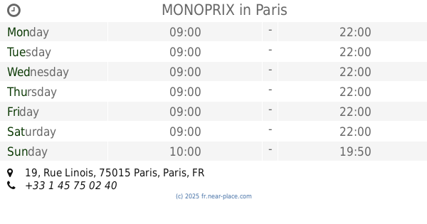
MONOPRIX
19 Rue Linois, Paris
Supermarket
read more
905 m
Monoprix
6 Rue Félix Faure, Paris
Supermarket
read more
925 m
Bio c' Bon
88 Avenue Félix Faure, Paris
Supermarket
read more
952 m
Carrefour City
45 Rue Lecourbe, Paris
Supermarket
read more
958 m
A2Pas
32 Boulevard de Grenelle, Paris
Supermarket
read more
986 m
My Auchan grenelle
28 Boulevard de Grenelle, Paris
Supermarket
read more
1.082 km
Naturalia
332 Rue Lecourbe, Paris
Supermarket
read more
1.252 km
Casino Shop
352 Rue Lecourbe, Paris
Supermarket
read more
📑
all categories
Accounting
Administrative area level 1
Administrative area level 2
Airport
Amusement park
Aquarium
Art gallery
Atm
Bakery
Bank
Bar
Beauty salon
Bicycle store
Book store
Bowling alley
Bus station
Cafe
Campground
Car dealer
Car rental
Car repair
Car wash
Casino
Cemetery
Church
City hall
Clothing store
Colloquial area
Convenience store
Country
Courthouse
Dentist
Department store
Doctor
Electrician
Electronics store
Embassy
Finance
Fire station
Florist
Food
Funeral home
Furniture store
Gas station
General contractor
Grocery or supermarket
Gym
Hair care
Hardware store
Health
Hindu Temple
Home goods store
Hospital
Insurance agency
Intersection
Jewelry store
Laundry
Lawyer
Library
Light rail station
Liquor store
Local government office
Locality
Locksmith
Lodging
Meal delivery
Meal takeaway
Mosque
Movie rental
Movie theater
Moving company
Museum
Natural feature
Neighborhood
Night club
Painter
Park
Parking
Pet store
Pharmacy
Physiotherapist
Place of worship
Plumber
Point of interest
Police
Political
Post office
Premise
Real estate agency
Restaurant
Roofing contractor
Route
Rv park, camping
School
Shoe store
Shopping mall
Spa
Stadium
Storage
Store
Subpremise
Subway station
Supermarket
Synagogue
Taxi stand
Train station
Transit station
Travel agency
University
Veterinary care
Zoo
administrative area level 3
sublocality level 1
↑