Supermarket nearby Carrefour
Coronavirus disease (COVID-19) Situation
confirmed cases
40138560
deaths
167642
France
Supermarket nearby Carrefour
Carrefour
15 Rue de Buci, Paris Francja
contacts phone
:
+33
Latitude:
48.8537448
, Longitude:
2.3376065
read more
nearest Supermarket
52 m
Market
79 Rue de Seine, Paris
Supermarket
read more
62 m
CSF France
60 Rue de Seine, Paris
Supermarket
read more
121 m
Bio c' Bon
60-62 Rue Saint-André des Arts, Paris
Supermarket
read more
321 m
Express
114 Boulevard Saint-Germain, Paris
Supermarket
read more
370 m
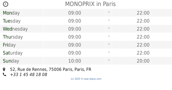
MONOPRIX
52 Rue de Rennes, Paris
Supermarket
read more
492 m
MONOPRIX
24 Boulevard Saint-Michel, Paris
Supermarket
read more
569 m
Express
7 Rue de Vaugirard, Paris
Supermarket
read more
575 m
Franprix
71 Rue de Rennes, Paris
Supermarket
read more
578 m
Carrefour City
75006 Rue de Rennes, Paris
Supermarket
read more
666 m
grocery store
7 Rue Saint-Jacques, Paris
Supermarket
read more
794 m
Carrefour Express Vaugirard Paris - Jean Bart
31 Rue de Vaugirard, Paris
Supermarket
read more
799 m
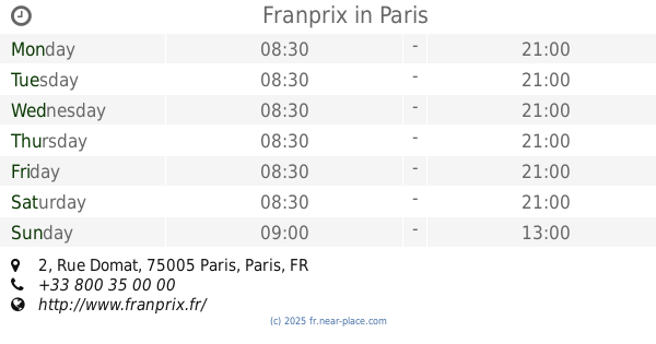
Franprix
2 Rue Domat, Paris
Supermarket
read more
804 m
MONOPRIX
Rue du Bac, Paris
Supermarket
read more
814 m
U Express
1 Rue d'Assas, Paris
Supermarket
read more
834 m
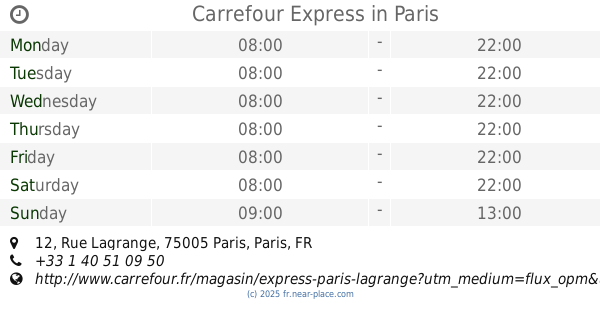
Carrefour Express
12 Rue Lagrange, Paris
Supermarket
read more
851 m
Franprix
14 Rue Lagrange, Paris
Supermarket
read more
903 m
MONOPRIX
6 Boulevard Raspail, Paris
Supermarket
read more
918 m
Carrefour City Beaupassage
57 Rue de Grenelle, Paris
Supermarket
read more
919 m
Proxi
182 Rue Saint-Jacques, Paris
Supermarket
read more
928 m
Naturalia
63 Rue du Bac, Paris
Supermarket
read more
993 m
Le Sumac
212 Rue Saint-Jacques, Paris
Supermarket
read more
1.014 km
Express
43 Boulevard Saint-Germain, Paris
Supermarket
read more
1.059 km
Carrefour City Paris Rivoli 80
80 Rue de Rivoli, Paris
Supermarket
read more
1.106 km
Aksou Mhammed
25 Rue de l'Abbé Grégoire, Paris
Supermarket
read more
1.122 km
Carrefour Express
27 Rue de l'Estrapade, Paris
Supermarket
read more
📑
all categories
Accounting
Administrative area level 1
Administrative area level 2
Airport
Amusement park
Aquarium
Art gallery
Atm
Bakery
Bank
Bar
Beauty salon
Bicycle store
Book store
Bowling alley
Bus station
Cafe
Campground
Car dealer
Car rental
Car repair
Car wash
Casino
Cemetery
Church
City hall
Clothing store
Colloquial area
Convenience store
Country
Courthouse
Dentist
Department store
Doctor
Electrician
Electronics store
Embassy
Finance
Fire station
Florist
Food
Funeral home
Furniture store
Gas station
General contractor
Grocery or supermarket
Gym
Hair care
Hardware store
Health
Hindu Temple
Home goods store
Hospital
Insurance agency
Intersection
Jewelry store
Laundry
Lawyer
Library
Light rail station
Liquor store
Local government office
Locality
Locksmith
Lodging
Meal delivery
Meal takeaway
Mosque
Movie rental
Movie theater
Moving company
Museum
Natural feature
Neighborhood
Night club
Painter
Park
Parking
Pet store
Pharmacy
Physiotherapist
Place of worship
Plumber
Point of interest
Police
Political
Post office
Premise
Real estate agency
Restaurant
Roofing contractor
Route
Rv park, camping
School
Shoe store
Shopping mall
Spa
Stadium
Storage
Store
Subpremise
Subway station
Supermarket
Synagogue
Taxi stand
Train station
Transit station
Travel agency
University
Veterinary care
Zoo
administrative area level 3
sublocality level 1
↑