Restaurant nearby McDonald's
Coronavirus disease (COVID-19) Situation
confirmed cases
40138560
deaths
167642
France
Restaurant nearby McDonald's
McDonald's
20 Avenue Jean Médecin, Nice Frankrig
contacts phone
:
+33
Latitude:
43.7001738
, Longitude:
7.2684806
read more
nearest Restaurant
154 m
Restaurant Don Carlo
7 Rue Paul Déroulède, Nice
Restaurant
read more
285 m
Jach restaurant
9 Rue Massena, Nice
Restaurant
read more
357 m
Les Épicuriens
6 Place Wilson, Nice
Restaurant
read more
479 m
A L'Italienne
14 Avenue Notre Dame, Nice
Restaurant
read more
512 m
Brasserie Le Mozart
11 Bis Avenue Baquis, Nice
Restaurant
read more
570 m
Restaurant China
d'Alsace- France, 12 Rue d'Alsace-Lorraine, Nice
Restaurant
read more
579 m
Lao Vientiane
12 Rue de la Buffa, Nice
Restaurant
read more
594 m
Turk Restaurant
Nice
Restaurant
read more
594 m
La Terrasse Restaurant
1 Promenade des Anglais, Nice
Restaurant
read more
614 m
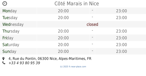
Côté Marais
4 Rue du Pontin, Nice
Restaurant
read more
635 m
Speed Burger Nice
50 Rue Lamartine, Nice
Restaurant
read more
656 m
Il Bolognese - Ristorante italiano
13B Cours Saleya, Nice
Restaurant
read more
680 m
Pacific
3 Rue du Pont Vieux, Nice
Restaurant
read more
711 m
L'Escale Saleya
28 Cours Saleya, Nice
Restaurant
read more
730 m
bar restaurant le raimbaldi
15 Boulevard Raimbaldi, Nice
Restaurant
read more
744 m
Le Hall
11 Rue du Collet, Nice
Restaurant
read more
753 m
Maki Bar
3 Rue du Collet, Nice
Restaurant
read more
770 m
Le Kobe sushi Jean Jaurès
8 Boulevard Jean Jaurès, Nice
Restaurant
read more
781 m
La Maison Bleue
15 Rue Meyerbeer, Nice
Restaurant
read more
806 m
Caju Vegan
2 Rue Sainte-Claire, Nice
Restaurant
read more
823 m
Chun Kan Kina
12 Avenue Saint-Jean-Baptiste, Nice
Restaurant
read more
824 m
Specialites nicoises
8 Rue de la Poissonnerie, Nice
Restaurant
read more
836 m
Le Barbecue
3 Rue du Four, Nice
Restaurant
read more
896 m
Cool Batbout
00024 Rue Trachel, Nice
Restaurant
read more
1.053 km
Le Chantecler
37 Promenade des Anglais, Nice
Restaurant
read more
📑
all categories
Accounting
Administrative area level 1
Administrative area level 2
Airport
Amusement park
Aquarium
Art gallery
Atm
Bakery
Bank
Bar
Beauty salon
Bicycle store
Book store
Bowling alley
Bus station
Cafe
Campground
Car dealer
Car rental
Car repair
Car wash
Casino
Cemetery
Church
City hall
Clothing store
Colloquial area
Convenience store
Country
Courthouse
Dentist
Department store
Doctor
Electrician
Electronics store
Embassy
Finance
Fire station
Florist
Food
Funeral home
Furniture store
Gas station
General contractor
Grocery or supermarket
Gym
Hair care
Hardware store
Health
Hindu Temple
Home goods store
Hospital
Insurance agency
Intersection
Jewelry store
Laundry
Lawyer
Library
Light rail station
Liquor store
Local government office
Locality
Locksmith
Lodging
Meal delivery
Meal takeaway
Mosque
Movie rental
Movie theater
Moving company
Museum
Natural feature
Neighborhood
Night club
Painter
Park
Parking
Pet store
Pharmacy
Physiotherapist
Place of worship
Plumber
Point of interest
Police
Political
Post office
Premise
Real estate agency
Restaurant
Roofing contractor
Route
Rv park, camping
School
Shoe store
Shopping mall
Spa
Stadium
Storage
Store
Subpremise
Subway station
Supermarket
Synagogue
Taxi stand
Train station
Transit station
Travel agency
University
Veterinary care
Zoo
administrative area level 3
sublocality level 1
↑