Restaurant nearby Le Run'Snack
France
Restaurant nearby Le Run'Snack
Le Run'Snack
199 Rue Jean Jaurès, Brest France
contacts phone
:
+33
Latitude:
48.3985447
, Longitude:
-4.4730445
read more
nearest Restaurant
23 m
Le Djerba
194 Rue Jean Jaurès, Brest
Restaurant
read more
55 m
Restaurant Traiteur Chez Zhou
189 Rue Jean Jaurès, Brest
Restaurant
read more
324 m
Sandwicherie iwago
149 Rue Jean Jaurès, Brest
Restaurant
read more
339 m
Le Cèdre
144 Rue Jean Jaurès, Brest
Restaurant
read more
435 m
Eurl Vieira
107 Rue Saint-Marc, Brest
Restaurant
read more
462 m
Chez Müller
29 Rue Navarin, Brest
Restaurant
read more
468 m
Horellou
31 Rue Navarin, Brest
Restaurant
read more
479 m
L'Atelier Gourmand
33 Rue Navarin, Brest
Restaurant
read more
616 m
Clinique De L Iroise
Rue Proudhon, Brest
Restaurant
read more
643 m
D Herouville Nelly
13 Rue Paul Masson, Brest
Restaurant
read more
647 m
route 66 Brest
20 Rue Charles Berthelot, Brest
Restaurant
read more
660 m
ANTALYA
3 Place de Strasbourg, Brest
Restaurant
read more
688 m
Kebab
rue 29200, 12 Rue Danton, Brest
Restaurant
read more
689 m
Les Caudalies
1 Rue Malakoff, Brest
Restaurant
read more
814 m
Gourmands et Cie
53 Boulevard Montaigne, Brest
Restaurant
read more
814 m
Fitamant Gisèle
53 Boulevard Montaigne, Brest
Restaurant
read more
839 m
Seo
5 Rue Coat ar Gueven, Brest
Restaurant
read more
843 m
Le Comptoir Gueven
5 Rue Coat ar Gueven, Brest
Restaurant
read more
935 m
McDonald's
Centre Commercial Coat Ar Gueven, 50 Rue Jean Jaurès, Brest Cedex
Restaurant
read more
1.019 km
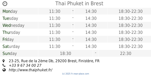
Thai Phuket
23-25 Rue de la 2ème Db, Brest
Restaurant
read more
1.116 km
La Minute Food.
3 Rue Frezier, Brest
Restaurant
read more
1.138 km
Crêpes et cakes
1 Rue de Glasgow, Brest
Restaurant
read more
1.165 km
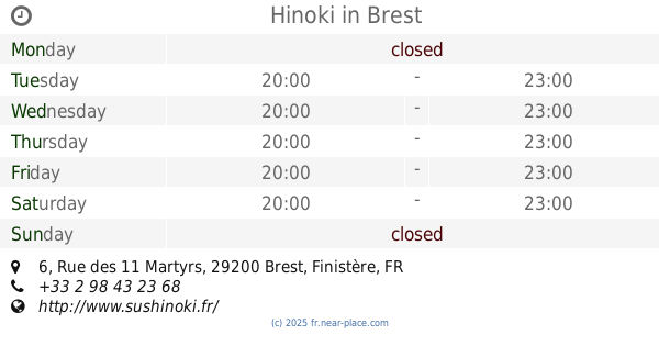
Hinoki
6 Rue des 11 Martyrs, Brest
Restaurant
read more
1.206 km
Brasserie BHV
1 Rue Jean Jaurès, Brest
Restaurant
read more
1.297 km
Ristorante Del Arte
14 Place de la Liberté, Brest
Restaurant
read more
📑
all categories
Accounting
Administrative area level 1
Administrative area level 2
Airport
Amusement park
Aquarium
Art gallery
Atm
Bakery
Bank
Bar
Beauty salon
Bicycle store
Book store
Bowling alley
Bus station
Cafe
Campground
Car dealer
Car rental
Car repair
Car wash
Casino
Cemetery
Church
City hall
Clothing store
Colloquial area
Convenience store
Country
Courthouse
Dentist
Department store
Doctor
Electrician
Electronics store
Embassy
Finance
Fire station
Florist
Food
Funeral home
Furniture store
Gas station
General contractor
Grocery or supermarket
Gym
Hair care
Hardware store
Health
Hindu Temple
Home goods store
Hospital
Insurance agency
Intersection
Jewelry store
Laundry
Lawyer
Library
Light rail station
Liquor store
Local government office
Locality
Locksmith
Lodging
Meal delivery
Meal takeaway
Mosque
Movie rental
Movie theater
Moving company
Museum
Natural feature
Neighborhood
Night club
Painter
Park
Parking
Pet store
Pharmacy
Physiotherapist
Place of worship
Plumber
Point of interest
Police
Political
Post office
Premise
Real estate agency
Restaurant
Roofing contractor
Route
Rv park, camping
School
Shoe store
Shopping mall
Spa
Stadium
Storage
Store
Subpremise
Subway station
Supermarket
Synagogue
Taxi stand
Train station
Transit station
Travel agency
University
Veterinary care
Zoo
administrative area level 3
sublocality level 1
↑