Restaurant nearby La presqu'ile
Coronavirus disease (COVID-19) Situation
confirmed cases
40138560
deaths
167642
France
Restaurant nearby La presqu'ile
La presqu'ile
10 Quai de la Douane, Brest France
contacts phone
:
+33
Latitude:
48.3818915
, Longitude:
-4.4873773
read more
nearest Restaurant
35 m
LATITUDE CREPE
4 Quai de la Douane, Brest
Restaurant
read more
171 m
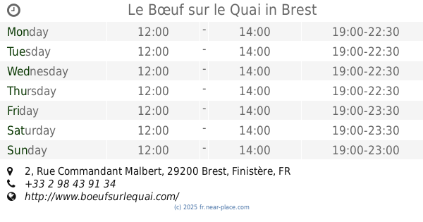
Le Bœuf sur le Quai
2 Rue Commandant Malbert, Brest
Restaurant
read more
229 m
Solignac Eric Jean Casimir
30 3ème Éperon, Brest
Restaurant
read more
301 m
Santa Cruz (El)
1 Rue de Narvik, Brest
Restaurant
read more
359 m
Arena Café
195 Quai Eric Tabarly, Brest
Restaurant
read more
410 m
Siam Factory
41 Place du Général de Gaulle, Brest
Restaurant
read more
505 m
Bougainvillier Le
3 Rue Ducouedic, Brest
Restaurant
read more
584 m
L'O à la Bouche
12 Rue de Siam, Brest
Restaurant
read more
586 m
Offside Bay
4 Rue de Siam, Brest
Restaurant
read more
594 m
Restaurant Les Ptites Recettes
40 Rue du Château, Brest
Restaurant
read more
604 m
mon resto
2 Rue de l'Elorn, Brest
Restaurant
read more
606 m
L'étable
13 Rue de Lyon, Brest
Restaurant
read more
623 m
Le Plaisir Des Mets
rue 29200, 44 Rue Jean Macé, Brest
Restaurant
read more
635 m
Restaurant Chez Carmine
4 Rue Louis Pasteur, Brest
Restaurant
read more
809 m
Restaurant Nautilus Brest
82 Rue de Siam, Brest
Restaurant
read more
897 m
Le Bodrum
18 Rue de la Porte, Brest
Restaurant
read more
905 m
Croisiere Samba Brest
23 Rue des Halles Saint-Louis, Brest
Restaurant
read more
923 m
Ripailles
40 Rue de Lyon, Brest
Restaurant
read more
944 m
Le Bosphore
26 Rue de la Porte, Brest
Restaurant
read more
967 m
Flo 2005
16 Place de la Liberté, Brest
Restaurant
read more
995 m
L'Eden
32 Rue Algésiras, Brest
Restaurant
read more
1.013 km
Restaurant Alanya
36 Rue Algésiras, Brest
Restaurant
read more
1.019 km
Brasserie BHV
1 Rue Jean Jaurès, Brest
Restaurant
read more
1.03 km
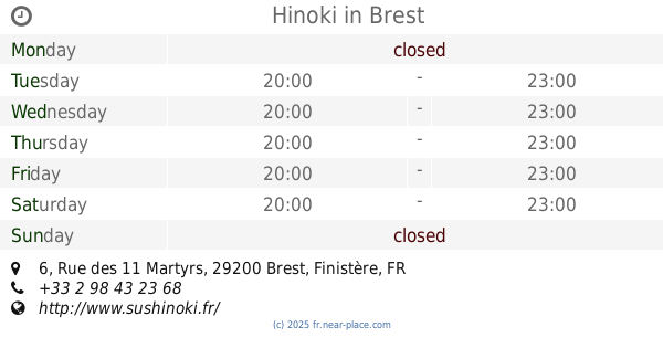
Hinoki
6 Rue des 11 Martyrs, Brest
Restaurant
read more
1.065 km
Asian Cafe.
58 Rue de Lyon, Brest
Restaurant
read more
📑
all categories
Accounting
Administrative area level 1
Administrative area level 2
Airport
Amusement park
Aquarium
Art gallery
Atm
Bakery
Bank
Bar
Beauty salon
Bicycle store
Book store
Bowling alley
Bus station
Cafe
Campground
Car dealer
Car rental
Car repair
Car wash
Casino
Cemetery
Church
City hall
Clothing store
Colloquial area
Convenience store
Country
Courthouse
Dentist
Department store
Doctor
Electrician
Electronics store
Embassy
Finance
Fire station
Florist
Food
Funeral home
Furniture store
Gas station
General contractor
Grocery or supermarket
Gym
Hair care
Hardware store
Health
Hindu Temple
Home goods store
Hospital
Insurance agency
Intersection
Jewelry store
Laundry
Lawyer
Library
Light rail station
Liquor store
Local government office
Locality
Locksmith
Lodging
Meal delivery
Meal takeaway
Mosque
Movie rental
Movie theater
Moving company
Museum
Natural feature
Neighborhood
Night club
Painter
Park
Parking
Pet store
Pharmacy
Physiotherapist
Place of worship
Plumber
Point of interest
Police
Political
Post office
Premise
Real estate agency
Restaurant
Roofing contractor
Route
Rv park, camping
School
Shoe store
Shopping mall
Spa
Stadium
Storage
Store
Subpremise
Subway station
Supermarket
Synagogue
Taxi stand
Train station
Transit station
Travel agency
University
Veterinary care
Zoo
administrative area level 3
sublocality level 1
↑