Park nearby Place Alexandre Vittone
France
Park nearby Place Alexandre Vittone
Place Alexandre Vittone
Saint-Étienne Francja
contacts phone
:
+33
Latitude:
45.4455593
, Longitude:
4.3812712
read more
nearest Park
263 m
Square Girodet
Saint-Étienne
Park
read more
272 m
Félix Thiollier Garden
Saint-Étienne
Park
read more
272 m
Jardin Félix Thiollier
Saint-Étienne
Park
read more
431 m
Place Sadi Carnot
4 Place Sadi Carnot, Saint-Étienne
Park
read more
576 m
Jardins de la Montée Bailly
Saint-Étienne
Park
read more
617 m
Square Victor Schoelcher
Saint-Étienne
Park
read more
629 m
Jardin Michel Olagnier
Saint-Étienne
Park
read more
637 m
Square Victor Schoelcher
7 Rue Ampère, Saint-Étienne
Park
read more
661 m
Square François Margand
Saint-Étienne
Park
read more
704 m
Place Maréchal Foch
Saint-Étienne
Park
read more
847 m
Square Pierre Chovet
Saint-Étienne
Park
read more
850 m
Comité d’Animation pour tous sur le Parc de Montaud
18 Rue Benoît Frachon, Saint-Étienne
Park
read more
850 m
Centre de Loisirs Parc de Montaud
18 Rue Benoît Frachon, Saint-Étienne
Park
read more
923 m
Parc de Montaud
41 Rue de Laharpe, Saint-Étienne
Park
read more
923 m
Park Montaud
41 Rue de Laharpe, Saint-Étienne
Park
read more
930 m
Place Jean - François Gonon
Saint-Étienne
Park
read more
941 m
Parc Joseph Sanguedolce
Saint-Étienne
Park
read more
994 m
Jardin Collectif des Moyens du Bord
Unnamed Road, 42000, Saint-Étienne
Park
read more
1.03 km
Parc François Mitterrand
Saint-Étienne
Park
read more
1.037 km
Place Paul Painlevé
Saint-Étienne
Park
read more
1.039 km
Square Docteur George Dujol
Saint-Étienne
Park
read more
1.159 km
Square Massenet
Saint-Étienne
Park
read more
1.163 km
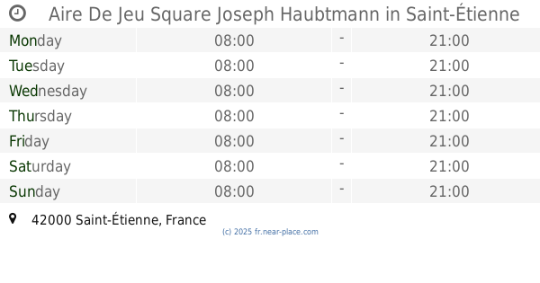
Aire De Jeu Square Joseph Haubtmann
Saint-Étienne
Park
read more
1.173 km
Square Joseph Haubtmann
Saint-Étienne
Park
read more
1.224 km
Square Violette
342 Rue Violette, Saint-Étienne
Park
read more
📑
all categories
Accounting
Administrative area level 1
Administrative area level 2
Airport
Amusement park
Aquarium
Art gallery
Atm
Bakery
Bank
Bar
Beauty salon
Bicycle store
Book store
Bowling alley
Bus station
Cafe
Campground
Car dealer
Car rental
Car repair
Car wash
Casino
Cemetery
Church
City hall
Clothing store
Colloquial area
Convenience store
Country
Courthouse
Dentist
Department store
Doctor
Electrician
Electronics store
Embassy
Finance
Fire station
Florist
Food
Funeral home
Furniture store
Gas station
General contractor
Grocery or supermarket
Gym
Hair care
Hardware store
Health
Hindu Temple
Home goods store
Hospital
Insurance agency
Intersection
Jewelry store
Laundry
Lawyer
Library
Light rail station
Liquor store
Local government office
Locality
Locksmith
Lodging
Meal delivery
Meal takeaway
Mosque
Movie rental
Movie theater
Moving company
Museum
Natural feature
Neighborhood
Night club
Painter
Park
Parking
Pet store
Pharmacy
Physiotherapist
Place of worship
Plumber
Point of interest
Police
Political
Post office
Premise
Real estate agency
Restaurant
Roofing contractor
Route
Rv park, camping
School
Shoe store
Shopping mall
Spa
Stadium
Storage
Store
Subpremise
Subway station
Supermarket
Synagogue
Taxi stand
Train station
Transit station
Travel agency
University
Veterinary care
Zoo
administrative area level 3
sublocality level 1
↑