Park nearby Le Jardin Des Vertueux
Coronavirus disease (COVID-19) Situation
confirmed cases
40138560
deaths
167642
France
Park nearby Le Jardin Des Vertueux
Le Jardin Des Vertueux
Chaussée Jules Ferry, Amiens Frankrig
contacts phone
:
+33
Latitude:
49.8779641
, Longitude:
2.3399558
read more
nearest Park
1.093 km
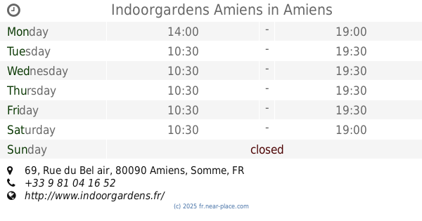
Indoorgardens Amiens
69 Rue du Bel air, Amiens
Park
read more
1.643 km
Place de La Victoire
Longueau
Park
read more
2.495 km
Promenade Nisso Pelossof
Amiens
Park
read more
2.506 km
Parc Jean-Rostand
Amiens
Park
read more
2.682 km
Square Beau Regard
Amiens
Park
read more
2.753 km
Square Aimé Césaire
80000 Rue Charles de Foucauld, Amiens
Park
read more
2.791 km
Square Jules Verne
Boulevard de Belfort, Amiens
Park
read more
2.844 km
Square de la Place du Maréchal Joffre
Place du Maréchal Joffre, Amiens
Park
read more
2.917 km
Square Joffre
Amiens
Park
read more
2.953 km
Parvis de l'Église Saint Martin
Rue Morgan, Amiens
Park
read more
2.993 km
Parc René Goblet
Place René Goblet, Amiens
Park
read more
3.037 km
Allée du chemin de fer
80000 Mail Albert 1er, Amiens
Park
read more
3.192 km
Parc de l'Evêché
Place Saint Michel, Amiens
Park
read more
3.277 km
St. Pierre Park
France
Park
read more
3.284 km
Square Jules Bocquet
Amiens
Park
read more
3.306 km
square Longueville
Place Longueville, Amiens
Park
read more
3.341 km
médiéval d'Amiens Garden
Amiens
Park
read more
3.341 km
Jardin médiéval d'Amiens
Amiens
Park
read more
3.441 km
Placette Lafleur
Venelle Lafleur, Amiens
Park
read more
3.48 km
Square Baptiste Marcet
Amiens
Park
read more
3.527 km
Square Édouard Dumuin
Petite Rue Saint-Leu, Amiens
Park
read more
3.723 km
Square Saint Germain
Rue Basse des Tanneurs, Amiens
Park
read more
3.755 km
Placette Sainte Catherine
Rue Sainte-Catherine, Amiens
Park
read more
4.469 km
NORD SEINE FORET 2A coopérative forestière - Agence d'Amiens
96 Rue Jean Moulin, Amiens
Park
read more
4.634 km
Jardin de l'église Saint Roch
80000 Rue Allou, Amiens
Park
read more
📑
all categories
Accounting
Administrative area level 1
Administrative area level 2
Airport
Amusement park
Aquarium
Art gallery
Atm
Bakery
Bank
Bar
Beauty salon
Bicycle store
Book store
Bowling alley
Bus station
Cafe
Campground
Car dealer
Car rental
Car repair
Car wash
Casino
Cemetery
Church
City hall
Clothing store
Colloquial area
Convenience store
Country
Courthouse
Dentist
Department store
Doctor
Electrician
Electronics store
Embassy
Finance
Fire station
Florist
Food
Funeral home
Furniture store
Gas station
General contractor
Grocery or supermarket
Gym
Hair care
Hardware store
Health
Hindu Temple
Home goods store
Hospital
Insurance agency
Intersection
Jewelry store
Laundry
Lawyer
Library
Light rail station
Liquor store
Local government office
Locality
Locksmith
Lodging
Meal delivery
Meal takeaway
Mosque
Movie rental
Movie theater
Moving company
Museum
Natural feature
Neighborhood
Night club
Painter
Park
Parking
Pet store
Pharmacy
Physiotherapist
Place of worship
Plumber
Point of interest
Police
Political
Post office
Premise
Real estate agency
Restaurant
Roofing contractor
Route
Rv park, camping
School
Shoe store
Shopping mall
Spa
Stadium
Storage
Store
Subpremise
Subway station
Supermarket
Synagogue
Taxi stand
Train station
Transit station
Travel agency
University
Veterinary care
Zoo
administrative area level 3
sublocality level 1
↑